Saturday, July 30, 2016

On to Cow Head - July 30, 2016


Driving southwest we passed barren lands made of limestone.


Newfoundland and Labrador became a province of Canada following WWII in March of 1949.  Many of the roads were initially built in the 1960's.  The growing season is especially short in the northern part of Newfoundland and the soil is shallow or composed of peat.  After the roads were built in the late 60's in this area, garden plots were planted along the roadside where soil had been hauled in as part of the road building process.  These gardens may be 10 miles or more from the nearest home.  We are not sure when they are tended but most of them look well kept.  Mostly there are potatoes growing but once and a while you see cabbage and turnip.


There was a huge area of vetch today when we stopped for a break.


Wild strawberries were growing there too.


There was a sled for hauling wood there too.


Underground Salmon Pool - Near the top of the Northern Peninsula, a few miles before Roddickton, NL, a sign points to the right on a gravel road, and eventually to a parking area, with signs showing trails. These will take you to Beaver Brook. The trail is not strenuous, but about 1.5 km. to the brook. Called a brook, but really more of a small river, it travels through an underground cavern - that is also the upstream route of Atlantic salmon travelling to spawning areas. 


If water conditions are appropriate, and there is mid-day light down into the tannin-brown water, Atlantic salmon can be seen lazing below or above the cavern. - Thanks goes to the Atlantic Salmon Federation for this information.

Allan gets credit for this picture that he took of the pool just before the salmon swim underground.  We counted over a dozen salmon at any given time in this pool.  Brian said that they were good sized and several were very big.  There were three people fly fishing down below the pool on the river.

Brian was itching to fish but because he is a nonresident he can only fish with a guide.


The view on the way to the underground salmon pool.


The Smith's van coming back out to the main road following our salmon pool visit.


We proceeded south and west and drove down that shore.


Apparently at some point in the year they lobster here.


Our next stop was to visit the Torrent River Salmon Interpretive Centre - It is in Hawke's Bay a short distance from the main road.   This boardwalk takes you from the parking lot to the center.  We have come across many boardwalks.  The ground has poor drainage and is often moist.  

At this site they have displays on the history of Atlantic salmon on the Torrent River and an underwater viewing station where you can look into the fishway that leads the salmon around a waterfall.  


They have a gate at the top of the fishway and a couple of times a day they open the gate for the fish to continue up the river.  When they open the gate they turn on a video camera that records their passage.  At a later time the video is viewed and the salmon are counted.  In recent days they have had from 53 to 167 salmon swim on by.

This is a picture of them behind the glass swimming in the fishway upstream.  Unfortunately my camera flashed which is probably not good for the fish and not great for the picture.


Allan captured this shot of a salmon trying to make it up and over the falls.  I doubt that he experienced success until he swam up the fishway, by the viewing spots and past the video camera.


Driving on down the coast we stopped at The Arches Provincial Park.  These naturally formed arches were created over the ages by tidal action. 


Here is my favorite back up photographer and chauffeur.  


Mother nature is quite powerful and grand.


This is just a sample of the variety of shapes, color and sizes of the stones at this location.


As we continued to Cow Head we could see the Long Range Mountains on our left and the Atlantic Ocean on our right.  This tree in the foreground is representative of the trees along this shoreline.  We were on a high bluff for much of our ride along the ocean today.  You can see the effect that the strong persistent wind from the ocean has had on its growth.

We will be here in Cow Head for two nights.  Our room faces Shallow Bay.  Just now at 9:36 pm we are experiencing a beautiful sunset.


St. Lunaire, NL - June 29

Oh how could it be!  We woke up this morning to no power.  Strong storms passed through in the wee hours and took the power with it.

We went out to breakfast hoping that the restaurant might have a generator.  No such luck.  So we kept on up the road to L'Anse aux Meadows National Historic Site.  We arrived a bit before it opened since we didn't get breakfast.  It was raining and several people were waiting by the door to the information center.  A Parc Canada guide came to the door and explained that the center was closed since they had no power.  Please come back after the power returned.  It was unfortunate but their emergency power was also not working.

We drove a bit more and were at the very northern inch of Newfoundland.  There was a small restaurant there. We stopped and a lady came out to tell us that she had no power and the restaurant was closed.  She suggested we go back 15-20 km to the small store and buy some bread, peanut butter and jelly and make sandwiches.

We returned to the cabins where we are staying.  Allan and I decided to remain at our cabin.  The others decided to take their chances driving to St. Anthony 30 minutes to the south in hopes of getting some Tim Horton coffee.

The power remained out all morning here at the cabin.  They returned at about noon and just as they got out of the van the power returned.  Lynn and I had hopes of doing laundry.  However, when we checked with the clerk she informed us that with the power out all morning she was way behind and we probably wouldn't be able to use the laundry facilities today.  

While in St. Anthony they were able to get coffee and something to eat in between the power being on and off.

Once again we headed to L'Anse aux Meadows National Historic Site, which is the only known Viking site in North America and the earliest evidence of Europeans in the western hemisphere.  Upon arrival the power was on but the cash registers were not up and running yet, so admission was free.  As you might imagine that was a nice side effect of losing power.

We toured the visitors center and watched the introductory 15 minute film.  Then we were given a guided walk to the reenactment site about .5 miles away across a somewhat barren landscape.  

Cow Parsnip - Heracleum Maximum


This is the "flower" of the bakeapple.  It unfurls and presents the bakeapple/cloudberry.  It is used in jams and jelly.  It has seeds larger than raspberries.  


This is the very nice park tour guide.  He grew up and lives just down the road from this archeological site.  As a boy he played on the mounds that were thought to be remnants of the Indians.  When he was about 12 the area was excavated by Swedish archeologists and the evidence of Norse were found that dated back 1,000 years.  

Years later when Parc Canada took over the site they covered the excavation sites to continue to preserve whatever is left and at some time in the future they may use the latest technology of the time and open up the site again.


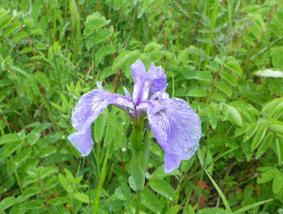
Blue Flag Iris - Iris Versicolor
Blue Flag iris like this one grow wild all around and about this area of Newfoundland.

Beyond where the archeologists worked, the park created a living history site.  They recreated structures to replicate what the evidence indicated was there from the time of the Norse presence.


I think the Norseman may have had mead in his cup.  And this might not have been his first cup of the day.  He was pretty friendly.


Lynn and I were greeted by this fella who wanted us to donate our silver earrings to him and he wanted us to be his slaves. An interesting offer but we both managed to exit the site when we were ready.  I think Jeff kept a close eye on this guy during our entire visit...


This woman is knitting a hat using a special needle and her thumbs.


They are thought to have been at the site for about 10 years.  The native peoples are suspected of letting them know that they were not welcome.


They probably wove to make patches for their sails.  The thread was made of wool.


The structures had no windows but this is the view looking out the door to the bay.


The walls of the structures were built from two rows of peat with gravel in between the the two walls of peat.


Beach Pea - Lathyrus Japonicus
No wonder I can't get sweet peas to grow in Florida.  They grow wide in this barren land.  


After dinner some of us rode back to St. Anthony and out to Fishing Point to look for whales and icebergs.  None were spotted.


Harebell - Campanula Rotundifolia
These harebells were spied growing out of a crevice high above the ocean. 


It was a beautiful evening.  On the way back it was 9:30ish and about dusk.  In two different places along the side of the road Brian spotted moose.  We were all glad that they stayed there for us to see and that they were not on the road.


Friday, July 29, 2016

Port Hope Simpson - L'Anse-au-Claire - St. Lunaire June 26-28

 Brian had a great time fishing with a guide in St. Lewis.  Lynn, Jeff and I joined Susan when she went back to pick him up. 
It was about a 40 minute ride south and east.

After we picked Brian and his guide up from the side of the road where they had been fishing we drove into the village to drop off the guide.  He was a kind retired gentleman who proceeded to direct us around town to see the sights.

He had us drive up a curvy, rough road to the highest point on the peninsula.  We could look out 360 degrees to see the bay, the ocean, lakes and land.  

There were some icebergs.  He called the small ones growlers. There was a large one just over the edge of land and we could see the tip.  The fog was coming in and it was getting late (8:15) so we did not take the path out to look over the cliff to get a good look.
It is near the end of the iceberg season.


This plaque is mounted on a rock at the top of the lookout.  Keep in mind that travel was done by boat and plane.  The current gravel road to town was completed in 2002.  Before that travel was only by snow
sleds and before that dog sleds.


This plaque is also up on the hill.


You can see the Atlantic Ocean behind Brian and Susan.  I got a picture of Lynn and Jeff but took it on their camera so don't have it to include here.

We peppered the guide with questions and learned a lot about his life and town.  He and his wife have two kids and they have both moved to Nova Scotia for work.  There are 30 students in the K-12 village school.  All of the vast forest lands that we have been traveling through in Labrador are owned by the "Crown."  

He gets a permit to harvest firewood and then gets it in the winter using a snowmobile and a sled.  He burns about 10 cord a season.  He harvests the black spruce that is the primary wood available.

He is 65 and retired from operating the town generator that makes the electricity for the 300 residents of the town.  Initially it was wood fired but by the time he retired it was diesel and controlled by computers.  He said at that point he didn't have to work very hard.

Historically, the town processed salmon and more recently cod. However, currently there is not much commercial industry in town.  Cod and snow crabs are landed there and transported elsewhere.

As we were dropping him off at his house he offered us a piece of iceberg.  Brian took a plastic grocery bag and got two pieces of iceberg from a chest freezer that he keeps in his shed.  When asked what he does with it, he shared that he chips off some and puts it in his rum.  I'm not sure quite what Brian will do with it but that sounds like a good use for 10,000 year old ice.

July 27


Cloudy, rainy and in the 50's.  We stopped for gas this morning and look what we saw!  That is a big enough hint for me.  It is about time to leave Labrador.


Jack the fishing guide told us that these sleds are hooked to snowmobiles and used to gather firewood.  He said they call them by their eskimo name, "qamutik".  We saw them in various locations along the side of the road.  These are very trusting folks.


More dirt road but we are now near the shore and have some ocean and bay views.


The Mildhogs in all our glory.  (r to l - Lynn & Jeff Fish, Susan & Brian Smith, Chris & Bill Fowler and Deb & Allan Metzler)
We are concerned for Jeff.  Looks like the harpoon is going to get him.  


Bill was quite excited to find an old friend!


This is a replica of the type of boat that the Basque used to sail across the Atlantic to come here to fish for whales in the 16th century.  They would kill whales and render the oil, place it in barrels and take it back.  The whale oil was then sold for lamp oil all across Europe.  They could fit up to 1,000 barrels in a ship.


This is a hooked rug.  The fabric used to hook was very fine.  The hanging depicts life in Red Bay during the four seasons.


This is the view outside of the museum looking up the bay.


On our way to our next stop L'Anse-au-Claire we saw a fin whale with its tail bobbing in the ocean.  We think it was feeding.  We also saw one breech.  It was a fantastic sight to behold.

We got settled into our next hotel and decided that we had time before dinner so we all took a ride in the van to a couple of lookout spots.  We drove through the next town which is where we were to catch the ferry the next day.  We went out to the ferry terminal to check out the location.  The ferry was just docking as we were there.

We went back to the hotel for dinner.  During dinner the power went out.  It stays light until about 9:30 so we had enough light to eat.  After a bit a generator kicked in but it was only for the lobby. We found our way back to our rooms and dug around for our flashlights.  Yes, as experienced travelers this has happened to us before.

July 28 - Cloudy and foggy, in the high 50's.

The ferry was leaving Blanc-Sablon at 10:30 and we knew we needed to arrive about an hour early.  We had a leisurely morning and were all packed and checked out by 9:00.  It was decided we would hang in the lobby for a while.  Finally, the desk clerk asked us if we were taking the 10:30 ferry.  Then she told us we needed to get going.

We arrive at 9:33.  Quickly we found out that they hold reservations until 1 hour before departure.  We no longer had reservations!!!  We were given numbers and they would board as many extras as the ship would hold.  We were numbers 42 and 43. They were able to board 21 extras.


Here is the ferry leaving without us.  We tried to make phone reservations for the 3:30 ferry.  They were no longer taking phone reservations.  The next available reservation was for Sunday afternoon, today is Thursday!  We were issued new numbers.  This time we got numbers 8 and 9.  We spent time watching for whales and we saw some.  We played cribbage.  I read my book.  We ate our packed lunch.  We were back and in line at 1:45.  We made it onto the 3:30 ferry.


The day is still gray but we are delighted to be here in Newfoundland.


We drove up the western shore and across to the east.  It is a small panhandle compared to the rest of the island.  There were many villages.


I'm partial to the ocean and loved the diversity of the scenery compared to the black spruce of Labrador.


The fog traveling over the mountain was breathtaking.


This was the view from the parking lot of a small store where we stopped for directions to our cabin.


This is the proud flag of Newfoundland and Labrador.  It was designed in 1980.  Newfoundland and Labrador became the 10th Canadian province in 1949.